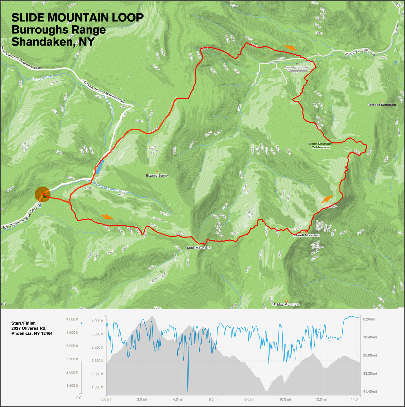
On Saturday, May 27, at 7:00 a.m. meet for a special run in the Catskills—the Slide Mountain/Burroughs Range Loop. This 14.5 mile loop offers 5,000 feet of elevation gain and crosses Slide Mountain (the highest peak in the Catskill range), Cornell, and Whittenberg. Meet at the Woods Bridge commuter lot in Katonah at 5:00 a.m. for the 2-hour drive to the start or you can meet at the Slide Mountain West Trail Head, 2027 Oliverea Rd, Phoenicia, NY 12464 (see Google Maps ››) at 7:00 a.m. We will make a counterclockwise loop starting shortly after 7:00 a.m. and finishing in the afternoon. Bring plenty of water, a filter if you have one, money, and a change of clothes so we can stop at the Phoenicia Diner afterward and eat all the foods. This is a challenging but fun adventure.
Run Calendar
Slide Mountain (Burroughs Range) Loop

WHERE AND WHEN
UPCOMING
Workout Wednesday—Kimberly Bridge
June 17 @ 5:30 am – 7:00 amAn event every week that begins at 5:30 am on Wednesday, repeating until December 18, 2025
Trail Thursday
June 18 @ 5:30 am – 7:00 amAn event every week that begins at 5:30 am on Thursday, repeating indefinitely
Fitness Friday
June 19 @ 5:45 am – 7:00 amTown Park to Green
June 21 @ 8:00 am – 9:30 amTrail Tuesday
June 23 @ 5:30 am – 7:00 amAn event every week that begins at 5:30 am on Tuesday, repeating indefinitely
Trail Thursday
June 25 @ 5:30 am – 7:00 amAn event every week that begins at 5:30 am on Thursday, repeating indefinitely
Trail Tuesday
June 30 @ 5:30 am – 7:00 amAn event every week that begins at 5:30 am on Tuesday, repeating indefinitely
Trail Thursday
July 2 @ 5:30 am – 7:00 amAn event every week that begins at 5:30 am on Thursday, repeating indefinitely
Trail Tuesday
July 7 @ 5:30 am – 7:00 amAn event every week that begins at 5:30 am on Tuesday, repeating indefinitely
Trail Thursday
July 9 @ 5:30 am – 7:00 amAn event every week that begins at 5:30 am on Thursday, repeating indefinitely
TRAIL DAMAGE REPORT
Help keep the trails clear by reporting downed trees or other conditions that the park should know about.
Report Damage ››
DONATE
STAY ON COURSE
The Free Avenza Maps software now has a free trail map of the Reservation available here. You can use that or the free GaiaGPS to load KML files of some of our runs as overlays. Now there’s no excuse to get lost.
