
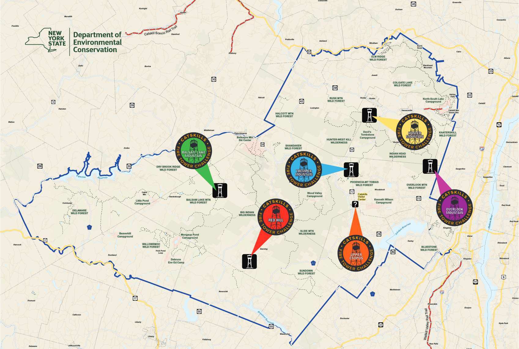
Woodstock-Elevation 3,140 feet

This is the newest of the five towers remaining in the Catskill Park, having been at its present location since 1950. However, the tower itself is much older as it was originally constructed in 1927 on Gallis Hill, just west of Kingston. The Overlook Tower reaches 60 feet in height, and offers incredible views of the Hudson River Valley, Ashokan Reservoir, and Devil’s Path.
Directions: Take the red-marked Overlook Spur Trail from Meads Mountain Road, just outside of downtown Woodstock – a moderate, six-mile, round-trip hike.
Town of Hunter-Elevation 4,040 feet
This tower has the unique distinction of being located at the highest elevation of any fire tower in New York State. The original tower on Hunter Mountain – constructed of logs – was built in 1909, and was the first of three fire towers constructed in the Catskills that year. The original tower was 40 feet tall, and was replaced with a steel tower 60 feet high in 1917. That tower was originally placed at an elevation of 4,000 feet – a third of a mile from the true summit – but was removed and reset at its present site on the true summit in 1953.
Directions: Take the Spruceton Trail marked with blue disks, from Greene County Route 6 (Spruceton Hollow Road) in the hamlet of Spruceton. A seven-mile moderately-difficult round trip hike. Or take the yellow-marked trail from the Hunter Mt. Sky Ride when it is open, a moderate four-mile round-trip hike.
Denning-Elevation 2,990 feet

The Red Hill Fire Tower stands 60 feet tall, has nine flights of stairs, and was constructed in 1921. This tower affords an unsurpassed view of the Catskill high peaks to the west and north, and the Rondout Reservoir to the southeast. It was the last fire tower staffed in the Catskills, closing in 1990.
Directions: Follow the yellow-marked Red Hill Tower Trail from Coons Road (formerly Dinch Road) just outside of Claryville-a moderate, three-mile, round-trip hike.
Hardenburgh-Elevation 3,723 feet

The first forest fire tower in New York State was erected on Balsam Lake Mountain in 1887.
Built of wood by the Balsam Lake Club, it survived until 1901 and was replaced with another wooden tower in 1905. Telephone lines, a small observer’s cabin, and a road to the summit were added in 1909, when the state took it over. The first steel tower was erected in 1919, and the present steel tower (47 feet tall) was built in 1930.
Directions: Follow the blue-marked Dry Brook Ridge Trail located on Mill Brook Road outside the hamlet of Arkville – a moderate, six-mile, round-trip hike.
Shandaken-Elevation 2,740 feet

This fire tower is believed to be the original structure built circa 1917, and was used for fire observation until 1971. The 47-foot tower was placed in its present location because of the vast sections of forest preserve not visible from either the Hunter or Belleayre fire towers.
Directions: Follow the red-marked Phoenicia Trail located on Ulster County Route 40 just outside of Phoenicia – a moderate to difficult, six-mile, round-trip hike.
Mt. Tremper

Located at the Catskills Visitor Center (leaves DEC website), the newest addition to the Catskills Visitor Center is a newly restored ’80 fire tower. Views from the fire tower include the Esopus Valley, nearby Mt. Tremper, Ashokan High Point, and the Phoenicia East Branch Trail. Access to the Fire Tower is available via the Interpretive Loop Trail. The Catskills Visitor Center building is open every day EXCEPT Tuesday from 9:30 a.m. to 4 p.m. The grounds are open to the public every day during daylight hours. Stop by on your way to the fire tower for latest park news, local maps and info, and more!
Directions: The Catskills Visitor Center is at 5096 Route 28 in Mt. Tremper. To access the Fire Tower, take the Interpretive Loop Trail around the back of the building.