

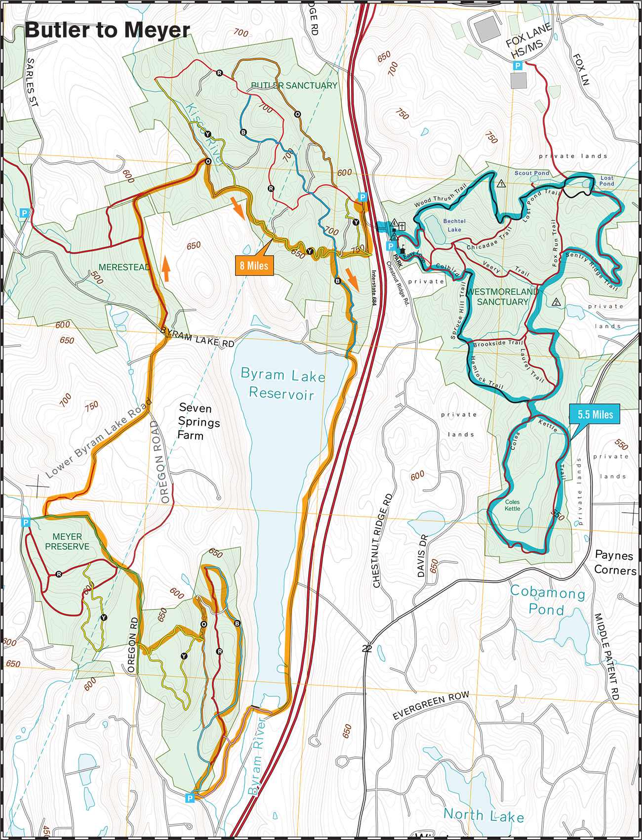
On Saturday, April 6, at 7:00 a.m., meet at Butler Sanctuary in Mt. Kisco ready to run the Bulter to Meyer course. It’s been over three years since we ran this course which includes a section of Byram Lake Road and Oregon Road so you’ll have an opportunity to stretch your legs plus get plenty of climb on the trails in Meyer and Bulter. Course should be around 8 miles but if you’re looking for a longer run, you can extend the course in Meyer or head over for a perimeter loop of Westmoreland and turn this into a half marathon. Early Risers can start at 6:00 for a perimeter loop of Butler and a view from the hawk watch before the main run. Afterwards, head over to Mimi’s in Mt. Kisco for a coffee, quiche, or your favorite recovery pastry.
Run Calendar
Butler to Meyer

WHERE AND WHEN
UPCOMING
Trail Tuesday
August 4 @ 5:30 am – 7:00 amAn event every week that begins at 5:30 am on Tuesday, repeating indefinitely
Workout Wednesday—Kimberly Bridge
August 5 @ 5:30 am – 7:00 amAn event every week that begins at 5:30 am on Wednesday, repeating until December 30, 2026
Trail Thursday
August 6 @ 5:30 am – 7:00 amAn event every week that begins at 5:30 am on Thursday, repeating indefinitely
Sights and Heights
August 8 @ 7:00 am – 8:30 amMichigan to Kimberly v1
August 9 @ 8:00 am – 10:00 amTrail Tuesday
August 11 @ 5:30 am – 7:00 amAn event every week that begins at 5:30 am on Tuesday, repeating indefinitely
Workout Wednesday—Kimberly Bridge
August 12 @ 5:30 am – 7:00 amAn event every week that begins at 5:30 am on Wednesday, repeating until December 30, 2026
Trail Thursday
August 13 @ 5:30 am – 7:00 amAn event every week that begins at 5:30 am on Thursday, repeating indefinitely
Fitness Friday
August 14 @ 5:45 am – 7:00 amAn event every week that begins at 5:45 am on Friday, repeating until December 18, 2026
Kimberly to Raven Rocks
August 15 @ 7:00 am – 9:00 amTRAIL DAMAGE REPORT
Help keep the trails clear by reporting downed trees or other conditions that the park should know about.
Report Damage ››
DONATE
STAY ON COURSE
The Free Avenza Maps software now has a free trail map of the Reservation available here. You can use that or the free GaiaGPS to load KML files of some of our runs as overlays. Now there’s no excuse to get lost.
