Skip to content

Sights and Heights v2

WardPoundRidge

Sights & Heights Loop, version 2

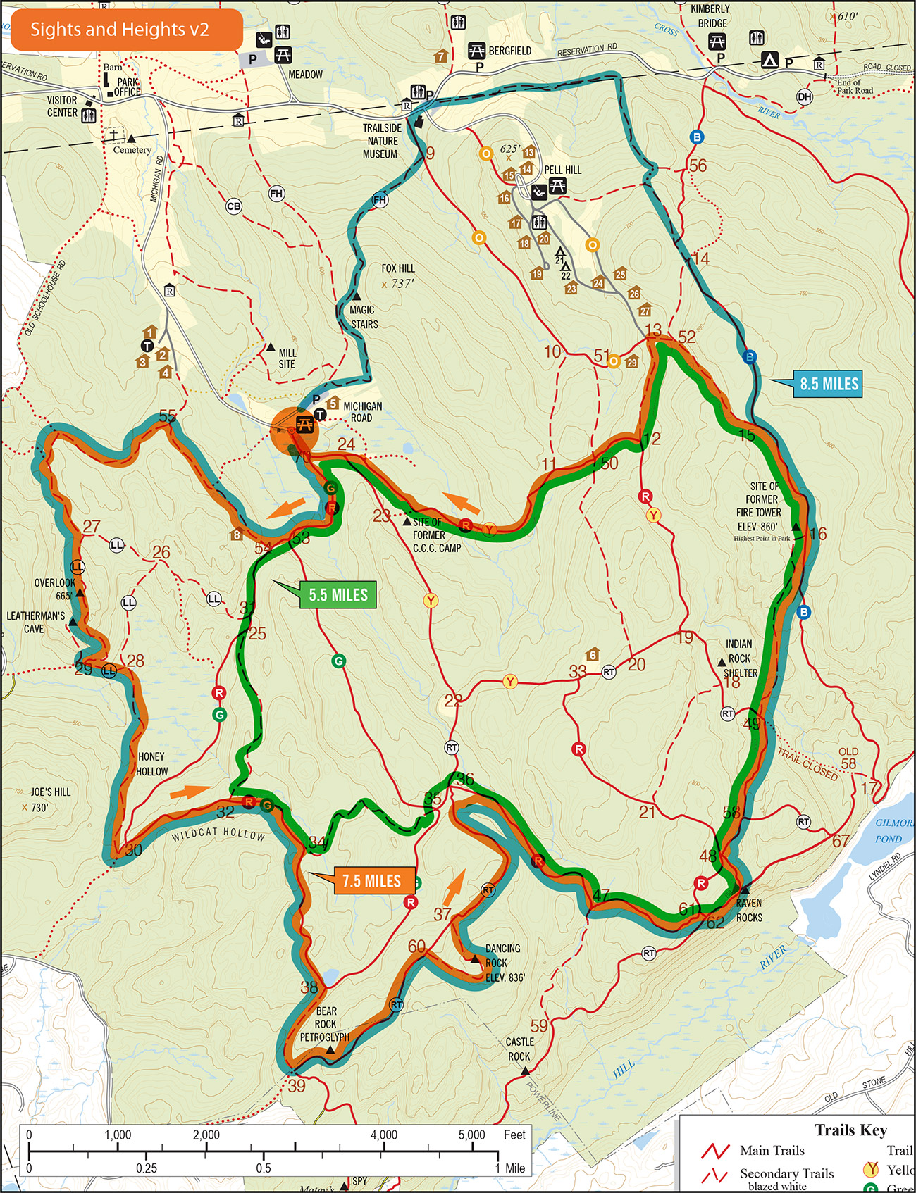
This version of the Sights & Heights loop takes runners to the Overlook Dancing Rock, Raven Rocks, and the Fire Tower—so, you’ll get some sights and some heights, as advertised. Options include heading back to Michigan Road after Raven Rocks and skipping the climb to the Fire Tower.

Upcoming

Dancing Rockish Run

May 11 @ 7:00 am - 9:00 am
Ward Pound Ridge Reservation, Michigan Road Lot
Michigan Road
Pound Ridge, NY 10576 United States
+ Google Map

Michigan to Kimberly V3

May 12 @ 8:00 am - 9:30 am
Ward Pound Ridge Reservation, Michigan Road Lot
Michigan Road
Pound Ridge, NY 10576 United States
+ Google Map

Trail Tuesday

May 14 @ 5:30 am - 7:00 am
Ward Pound Ridge Reservation, Michigan Road Lot
Michigan Road
Pound Ridge, NY 10576 United States
+ Google Map

Workout Wednesday—Blue Hill Repeats

May 15 @ 5:30 am - 7:00 am
Ward Pound Ridge Reservation, Kimberly Bridge
Reservation Road
Pound Ridge, NY 10576 United States
+ Google Map

Trail Thursday

May 16 @ 5:30 am - 7:00 am
Ward Pound Ridge Reservation, Michigan Road Lot
Michigan Road
Pound Ridge, NY 10576 United States
+ Google Map

Trail Tuesday

May 21 @ 5:30 am - 7:00 am
Ward Pound Ridge Reservation, Michigan Road Lot
Michigan Road
Pound Ridge, NY 10576 United States
+ Google Map

Workout Wednesday—Blue Hill Repeats

May 22 @ 5:30 am - 7:00 am
Ward Pound Ridge Reservation, Kimberly Bridge
Reservation Road
Pound Ridge, NY 10576 United States
+ Google Map

Trail Thursday

May 23 @ 5:30 am - 7:00 am
Ward Pound Ridge Reservation, Michigan Road Lot
Michigan Road
Pound Ridge, NY 10576 United States
+ Google Map

Trail Tuesday

May 28 @ 5:30 am - 7:00 am
Ward Pound Ridge Reservation, Michigan Road Lot
Michigan Road
Pound Ridge, NY 10576 United States
+ Google Map

Workout Wednesday—Blue Hill Repeats

May 29 @ 5:30 am - 7:00 am
Ward Pound Ridge Reservation, Kimberly Bridge
Reservation Road
Pound Ridge, NY 10576 United States
+ Google Map

Stay On Course

The Free Avenza Maps software now has a free trail map of the Reservation available here. I’ll make .kml files available as I can so you can load them as layer overlays. Now there’s no excuse to get lost.

Donate

Help keep the site running, kick in something for a night run, or help share the cost of special events by donating. Any amount accepted. Thanks.