
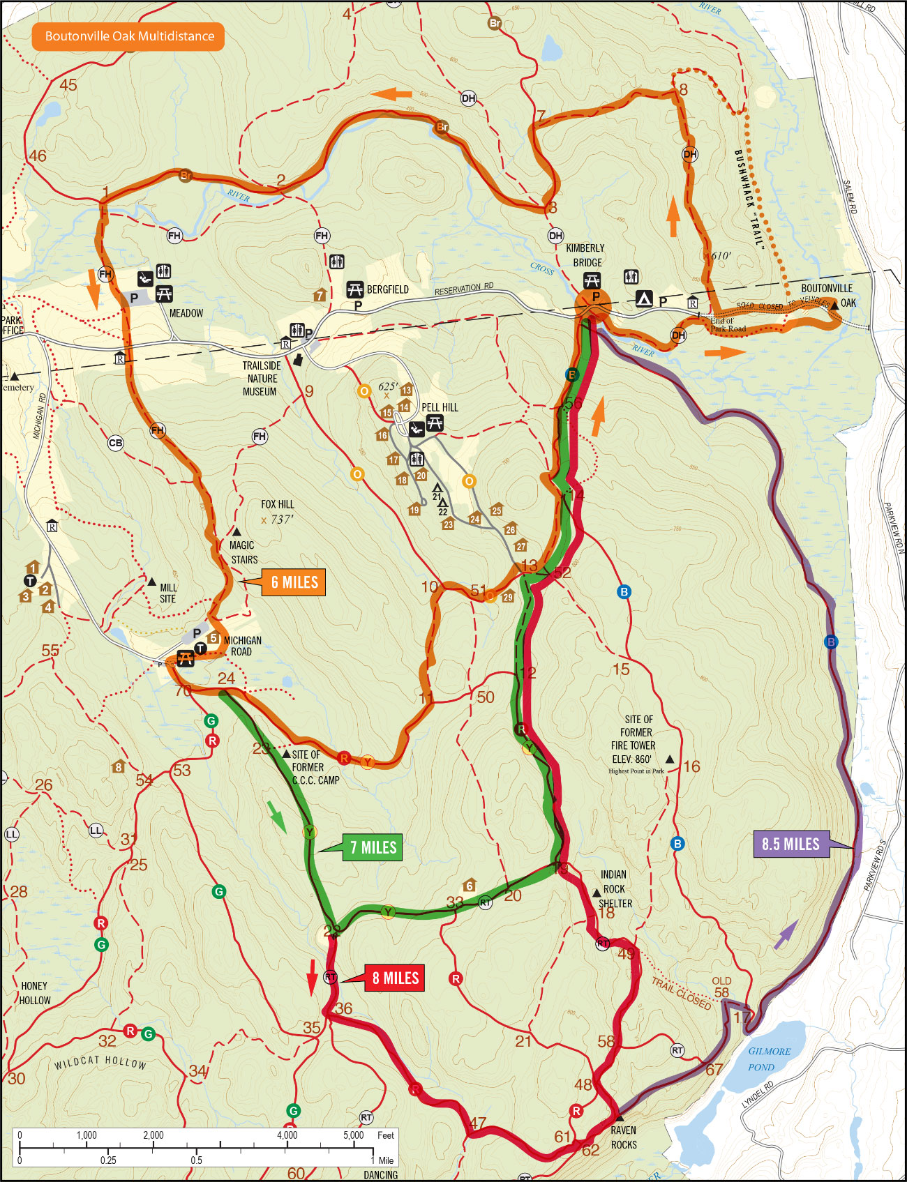
Boutonville Oak Multidistance
This course offers runners a chance to see the Boutonville Oak, a storied landmark on the eastern side of the reservation. Distances range from 6 miles to 8.5 miles and there’s the option of taking the bushwhack trail near the oak which leads to the top of the sand hill. Plenty of options on this map to be sure.
Upcoming
Trail Tuesday

Ward Pound Ridge Reservation, Michigan Road Lot
Michigan Road
Pound Ridge, NY 10576 United States + Google Map
Pound Ridge, NY 10576 United States + Google Map
Workout Wednesday—Trailside Museum

Trailside Museum
Reservation Road
Pound Ridge, NY 10576 United States + Google Map
Pound Ridge, NY 10576 United States + Google Map
Trail Thursday

Ward Pound Ridge Reservation, Michigan Road Lot
Michigan Road
Pound Ridge, NY 10576 United States + Google Map
Pound Ridge, NY 10576 United States + Google Map
Run the Numbers Part 4

Ward Pound Ridge Reservation, Michigan Road Lot
Michigan Road
Pound Ridge, NY 10576 United States + Google Map
Pound Ridge, NY 10576 United States + Google Map
Mudders & Grunters or Trailside & Town Park
Trailside Museum
Reservation Road
Pound Ridge, NY 10576 United States + Google Map
Pound Ridge, NY 10576 United States + Google Map
Trail Tuesday
Ward Pound Ridge Reservation, Michigan Road Lot
Michigan Road
Pound Ridge, NY 10576 United States + Google Map
Pound Ridge, NY 10576 United States + Google Map
Workout Wednesday—Trailside Museum
Trailside Museum
Reservation Road
Pound Ridge, NY 10576 United States + Google Map
Pound Ridge, NY 10576 United States + Google Map
Trail Thursday
Ward Pound Ridge Reservation, Michigan Road Lot
Michigan Road
Pound Ridge, NY 10576 United States + Google Map
Pound Ridge, NY 10576 United States + Google Map
Red/Rock Trail Loop

Ward Pound Ridge Reservation, Michigan Road Lot
Michigan Road
Pound Ridge, NY 10576 United States + Google Map
Pound Ridge, NY 10576 United States + Google Map
Trail Tuesday
Ward Pound Ridge Reservation, Michigan Road Lot
Michigan Road
Pound Ridge, NY 10576 United States + Google Map
Pound Ridge, NY 10576 United States + Google Map