No products in the cart.

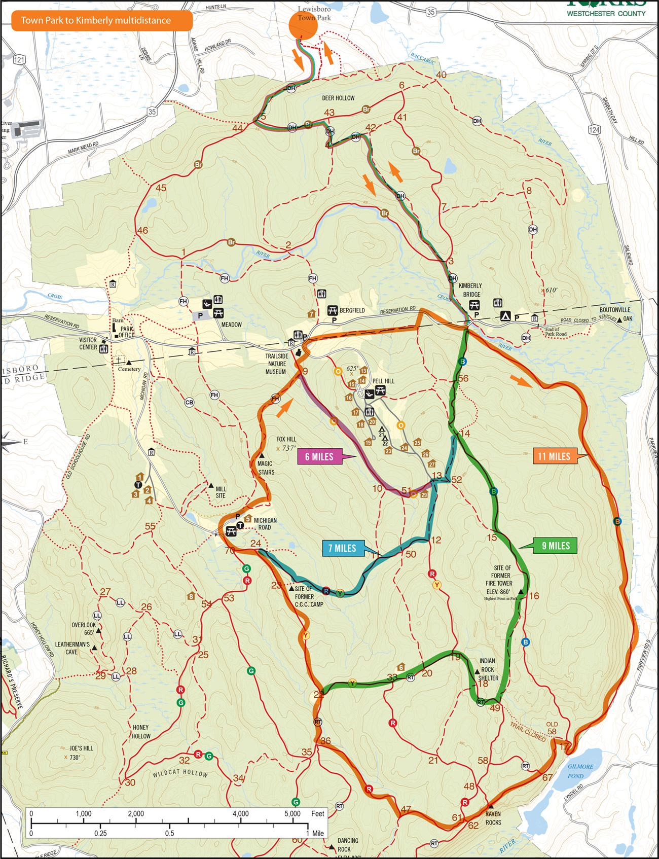
Lewisboro Town Park to Kimberly Multidistance Loops
This course starts at Lewisboro Town Park and makes its way to Kimberly Bridge. From there, runners have a choice of loops to complete from 6 to 11 miles. Note that the courses follow an unusual turn after the Trailside Museum—down the hill to the road—before you return to Kimberly Bridge.
Upcoming
Trail Tuesday

Ward Pound Ridge Reservation, Michigan Road Lot
Michigan Road
Pound Ridge, NY 10576 United States + Google Map
Pound Ridge, NY 10576 United States + Google Map
Workout Wednesday—Trailside Museum

Trailside Museum
Reservation Road
Pound Ridge, NY 10576 United States + Google Map
Pound Ridge, NY 10576 United States + Google Map
Trail Thursday

Ward Pound Ridge Reservation, Michigan Road Lot
Michigan Road
Pound Ridge, NY 10576 United States + Google Map
Pound Ridge, NY 10576 United States + Google Map
Run the Numbers Part 4

Ward Pound Ridge Reservation, Michigan Road Lot
Michigan Road
Pound Ridge, NY 10576 United States + Google Map
Pound Ridge, NY 10576 United States + Google Map
Mudders & Grunters or Trailside & Town Park
Trailside Museum
Reservation Road
Pound Ridge, NY 10576 United States + Google Map
Pound Ridge, NY 10576 United States + Google Map
Trail Tuesday
Ward Pound Ridge Reservation, Michigan Road Lot
Michigan Road
Pound Ridge, NY 10576 United States + Google Map
Pound Ridge, NY 10576 United States + Google Map
Workout Wednesday—Trailside Museum
Trailside Museum
Reservation Road
Pound Ridge, NY 10576 United States + Google Map
Pound Ridge, NY 10576 United States + Google Map
Trail Thursday
Ward Pound Ridge Reservation, Michigan Road Lot
Michigan Road
Pound Ridge, NY 10576 United States + Google Map
Pound Ridge, NY 10576 United States + Google Map
Red/Rock Trail Loop

Ward Pound Ridge Reservation, Michigan Road Lot
Michigan Road
Pound Ridge, NY 10576 United States + Google Map
Pound Ridge, NY 10576 United States + Google Map
Trail Tuesday
Ward Pound Ridge Reservation, Michigan Road Lot
Michigan Road
Pound Ridge, NY 10576 United States + Google Map
Pound Ridge, NY 10576 United States + Google Map